Examining marine species distribution patterns can help to assess risks from human activities and to understand how these distribution patterns are changing in response to climate change.
Current Projects
Aerial Surveys of Wind Energy Areas in Massachusetts and Rhode Island
The New England Aquarium has been conducting aerial surveys since 2011 of an area sited for wind energy development off Massachusetts and Rhode Island. This research is conducted in collaboration with the Massachusetts Clean Energy Center, Bureau of Ocean Energy Management, and individual wind energy development companies. These surveys collect data on the distribution and abundance of marine mammals and turtles. These data are critically important for mitigating effects of wind energy construction and operation on protected species. This project has also collaborated with Cornell University to collect acoustic data and Woods Hole Oceanographic Institution to collect oceanographic data and conduct prey sampling. Analyses conducted using these data include estimating species abundance, developing models to understand species habitat, and assessing trends in the abundance and demographic patterns of right whales.
https://www.youtube.com/watch?v=Q5bG1qN6N1I&t=14s
- Lead: Jessica Redfern, Orla O’Brien
Aerial surveys of the Northeast Canyons and Seamounts Marine National Monument
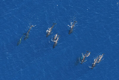
Located approximately 150 miles off the coast of Cape Cod, the Northeast Canyons and Seamounts Marine National Monument is the first and only marine national monument off the continental United States. The monument was designated in 2016, with the help of NEAq scientists. Our researchers have been conducting aerial surveys of the Monument since 2017 to collect valuable species distribution data. Although this remote area is difficult to survey, each flight yields amazing offshore sightings, including sperm whales, blue whales, beaked whales, large pods of dolphins, and whale sharks. These surveys have demonstrated an incredible diversity and abundance of marine mammals in the Monument and lend support to the case for its continued protection.
- Lead: Jessica Redfern, Orla O’Brien
Redfern, J. V., K. A. Kryc, L. Weiss, B. C. Hodge, O. O’Brien, S. D. Kraus, E. Quintana-Rizzo, and P. J. Auster. 2021. Opening a Marine Monument to Commercial Fishing Compromises Species Protections. Frontiers in Marine Science 8.
Auster, P.J., Hodge, B.C., McKee, M.P., & Kraus, S.D. (2020). A scientific Basis for Designation of the Northeast Canyons and Seamounts Marine National Monument. Frontiers in Marine Science, 7, 566.
Marine Mammal Species Diversity
Features that support marine mammal foraging have been suggested as important components to include in Marine Protected Areas, but research is needed to understand the relationship between these features and diversity. For example, the Northeast Canyons and Seamounts Marine National Monument (hereafter, Monument) represents an area known to support marine mammal foraging and was designated to protect an area of high marine mammal diversity. However, no comparisons have been made between marine mammal diversity in the Monument and other areas. This research increases our understanding of what makes the Monument unique by identifying how species diversity in the monument is different from diversity in the Northwest Atlantic Ocean. This research also helps identify sites in U.S. East Coast waters that could be considered candidates for meeting the goal of protecting 30% of areas of particular importance to biodiversity (i.e., 30×30).
- Lead: Jessica Redfern, Dan Pendleton
Habitat Use and Species Distribution Modeling
Habitat modeling is a broad area of research that encompasses a vast array of techniques to answer questions about where animals will be and when, which are critical questions to answer in marine conservation. Our scientists use abundance estimation, occupancy modeling, and density surface modeling to explore the past, present, and future of large whale habitat use. Abundance estimation uses survey data to calculate the number of animals present in an area over a period of time (e.g., yearly, seasonally). Species distribution models, such as occupancy modeling and density surface modeling, expand upon abundance estimation by identifying relationships between abundance and environmental conditions. Occupancy models estimate the probability of habitat use for a species and can combine data from multiple survey programs with varying protocols. Density surface modeling uses spatial reference data (e.g., habitat data, bathymetry, or latitude and longitude) to estimate the variation in animal abundance within a study area. The models we use to generate occupancy and density estimates can also be used to forecast whale distributions. Forecasting whale distributions can be a valuable tool for identifying areas of new habitat use that may require management actions to protect whales.
- Lead: Jessica Redfern, Dan Pendleton, Laura Ganley, Orla O’Brien
Redfern, J.V., Moore, T.J., Fiedler, P.C., de Vos, A., Brownell, R.L., Forney, K.A., Becker, E.A. & Ballance, L.T. 2017 Predicting cetacean distributions in data-poor marine ecosystems. Diversity and Distributions 23: 394-408.
Pendleton, D.E., Sullivan, P.J., Brown, M.W., Cole, T.V.N., Good, C.P., Mayo, C.A., Monger, B.C., Phillips, S., Record, N.R. and Pershing, A.J. (2012). Weekly predictions of North Atlantic right whale Eubalaena glacialis habitat reveal influence of prey abundance and seasonality of habitat preferences. Endangered Species Research 18:147–161. doi.org/10.3354/esr00433